|
|
Puerto Peþasco (Rocky Point) |
| Home Page | About Us | City Description | Hotels | Villa, B& B's | Restaurants | Golf + Activities | Sightseeing | Destination Services | RV/Trailer Parks & Hostels | Travel Value Packages | Airlines | Other Cities in Mexico | What's New | General Info | State Map | Regional Map | Country Map | Blog |
| Nearby Cities -> | Hermosillo | Nogales | |
|
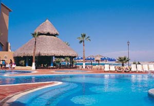
Situated on the Sea of Cortez - Gulf of California in northern Sonora, Puerto Peþasco is a popular weekend playground for folks from Arizona. It's a three hour drive from Tucson on a fairly good highway. Virtually unpopulated, the scenery, flora and fauna change as one descends to sea-level.
Historically, the Rocky Point area started acquiring interest from the US after the Mexican-American War of 1848 as a location for a US port on the Sea of Cortez. Interest in developing a US railroad route to the Pacific through a part of what was still Northern Mexico in what is now Arizona, shifted attention from Puerto Peþasco to the Mesilla/Las Cruces, New Mexico area. This led to the Gadsen Purchase of 1854. During Prohibition, the infamous Al Capone built a dock, opened a Casino and other facilities in Puerto Peþasco in an attempt to extend his area of activity. As Mexican authorities started making it more difficult for him and his cronies, he ordered the casino and dock blown up and left. During World War II, fear of a Japanese attack on western US shipping operations, prompted paving the dirt road between Sonoita and Puerto Peþasco. Nowadays, Rocky Point's tourism infrastructure includes trailer/rv parks, condominiums, hotels and a wide variety of restaurants and bars. Popular activities include fishing, whale-watching in the winter time, quad-riding, sailing, scuba diving, snorkeling, sky-diving and many others. |
|
|
External links:
|
| Home Page | About Us | City Description | Hotels | Villa, B& B's | Restaurants | Golf + Activities | Sightseeing | Destination Services | RV/Trailer Parks & Hostels | Travel Value Packages | Airlines | Other Cities in Mexico | What's New | General Info | State Map | Regional Map | Country Map | Blog |
|
This page was last modified in the Mexico Travel Database on January 31, 2012 |
| Powered by DataPerfect |